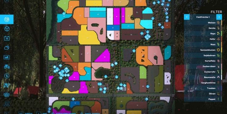
AutoDrive route network for the “Kleines Bergland” map from LS Schleswig Holstein
I tested the route network with various vehicles (see below).
Nevertheless, it can of course happen that it does not fit 100% at one point or another.
Please report this to me so I can correct it or correct it for yourself.
The map is generally designed for vehicles, trailers & Co. up to a maximum of medium size. Therefore, trailers with more than 2 axles should be avoided.
If bushes bother you because of their collision, I recommend removing them with a pruner or removing the packages with “Map Objects Hider”.
Was retracted:
The courtyard: all unloading and removal points, drive-through silos, stables including pasture, 4 parking spaces in halls, workshop (the trigger on the tank barrel is still wrong)
All fields and meadows (catch lines including field islands): Some descent points can unfortunately only be reached by driving across the field/field edge (map technically not otherwise implementable at the moment)
All productions except Spinnerei (only target point because too narrow)
All purchase and sales points as well as BGA including drive-through silos
All petrol stations: some should be approached without a trailer (e.g. Mitte)
The building site has only one access point (dead end)
Small “braking points” are installed in front of speed cameras and traffic lights
Note: the appropriate map and vehicle settings have already been made in the config.
Activate folders, collision height above ground at 2m, collision detection at FS 19, max. silo distance at 25m
Abbreviations at the destinations:
Anl. = delivery, unloading
Ent. = removal, collection
EK = purchase
VK = sale
Test vehicles (no mods):
Tractors: Claas Axion 900 & Fendt 900, each with wide tires + AgriBumper
Trailer: Claas Carat 140 TD, Fliegl ASW-271, Strautmann Aperion 3401
Thresher: Claas Trion 750 + Convio Flex 1080 on Nardi N60-35 header trailer
Truck: MAN TGS 18.500 + Lizard MKS 32 & Krampe SKS 30/1050
Enjoy my course!

